Walks around North Meols
Walk A
Commencing at the Fog Bell building on Marshside Road (bus stop route 42)
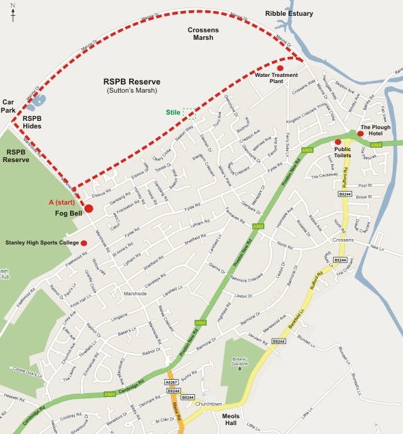
Walk towards the coast crossing Elswick Road.
On top of the rise – the 1892 sea embankment now part of the Sefton Coastal Path - turn right onto the path and continue until you reach the stile. The land on your left is part of the RSPB Marshside Nature Reserve and is known as Sutton’s Marsh (after the local Farmer). Several species of wading birds are visible throughout the year.
At the stile there is an option to take a route to Botanic Gardens and Churchtown Village (route D).
Continuing on over the stile, the land on the left is privately owned. Passing the Water Treatment plant the path meets the Marine Drive (coastal road). To reach the nearest bus route, public house (the Plough) or public toilets, turn right and follow the footpath signs.
Turning left takes you round the Marine Drive. Take care as the speed limit is 50mph. On the seaward side is a view across the Ribble Estuary to Blackpool and the Fylde Coast. Again this is an internationally recognised important area for wading birds. On the left hand side there is a different view of Sutton’s Marsh. A good view of the wading birds can be seen along Polly’s Creek into Polly’s Pool.
A few metres further on the left, there is the path leading to the main RSPB hide, Sandgrounder’s Hide (Sandgrounder is the name given to people who are locally born and bred). The hide is usually manned by volunteers, between 9am and 5pm every day and they will be pleased to answer any questions.
Continuing past the Hide you will come to Marshside Road. Turning left at this point will take you back to the Fog Bell.
Alternative Route and Car Parking
Car Parking is available close to the RSPB hide at the junction of Marshside Road and Marine Drive.
We hope you enjoy our suggestion for a ‘Walk on the Old and Wild Side&rsuo;