Churchtown Village Trail
Churchtown Village Trail
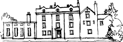
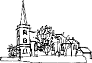 1. ST CUTHBERT’S CHURCH is
believed to have been built on the site of a church dating from pre-Conquest times. A place called Mele is one
of the twelve resting places, in Lancashire, of the bones of St Cuthbert during their wanderings in the 9th Century.
1. ST CUTHBERT’S CHURCH is
believed to have been built on the site of a church dating from pre-Conquest times. A place called Mele is one
of the twelve resting places, in Lancashire, of the bones of St Cuthbert during their wanderings in the 9th Century.
The church was built in stone in 1571 and rebuilt in 1730-39, although very little of this now remains. The south door bears the inscription: “James Rimmer, Thomas Rimmer, Robert Ball, Church Wardens. James Whitehead Rector 1730”. The tower and spire were rebuilt in 1850.
2. THE STOCKS are sited in St Cuthbert’s Road adjacent to the church walls and may have been built by a John Linaker in 1741. They were last used in 1860 when they held a John Rimmer for drunkenness.
In 2017 a campaign was begun to restore the Stocks and ensure their long term future.
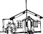 3. THE GRAMMAR SCHOOL is the
building now housing the Conservative Club.
3. THE GRAMMAR SCHOOL is the
building now housing the Conservative Club.
It was originally built in 1729 and was converted to a National School in 1826. The school moved to a new building in 1889 when it was known as St Cuthbert’s Church of England School.
In 1911 the school was demolished and the present Churchtown Primary School was built by Southport Corporation and was known as Southport Churchtown Council School.
4. THE CIVIC SOCIETY GARDEN was opened in 1992 as the North Meols Civic Society’s contribution to the town’s Bicentenary celebrations. Originally the site of an ancient orchard and also the line of a track from the village to Sally’s Farm.
Find out more about the Civic Society’s garden
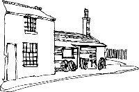
 5. THE TRAM SHEDS were built in 1878 when
the tramway owned by the Southport Tramway Co. extended its tracks along Cambridge Road. Prior to that the
trams ran from Birkdale via Weld Road, York Road, Aughton Road, Lord Street, Manchester Road, Roe Lane,
Mill Lane, and Botanic Road to the terminus at what is now the Botanic Gardens.
5. THE TRAM SHEDS were built in 1878 when
the tramway owned by the Southport Tramway Co. extended its tracks along Cambridge Road. Prior to that the
trams ran from Birkdale via Weld Road, York Road, Aughton Road, Lord Street, Manchester Road, Roe Lane,
Mill Lane, and Botanic Road to the terminus at what is now the Botanic Gardens.
The trams were converted to electric traction in 1900 and to omnibus service on 1st January 1935. Now the site of a new property development, only a gable-end of the old sheds remains.
6. SUGAR HILLOCKS or SUGAR HOUSES formed part of a ‘cop’ or sea embankment and was the name given to the place where a cargo of sugar and potatoes was washed up from a shipwreck in 1575. Potatoes were first grown in England in this area as a consequence of this shipwreck.
The Hillock later became the site of the Churchtown Railway Station. The Churchtown Railway Station once occupied the site where the Health Clinic now stands. It was opened in 1882 and served the village until it was closed as part of the Beeching cuts in the 1960s. The line went from Chapel Street Station via St Lukes (Rose Hill - Ash Street) Station, Hesketh Park (Preston Road) Station, Churchtown, Crossens, and on to Preston. It was known as the Celery Line because of the market gardens it serviced.
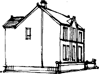
 7. BOLD HOUSE is situated at
36 Manor Road and was originally built prior to 1554. The present building dates from
1802. The site is where Kirkgate (now Churchgate) joined Marshside Lane
(now Manor Road). This junction is where the Post Office now stands.
7. BOLD HOUSE is situated at
36 Manor Road and was originally built prior to 1554. The present building dates from
1802. The site is where Kirkgate (now Churchgate) joined Marshside Lane
(now Manor Road). This junction is where the Post Office now stands.
8. The FARMER’S ARMS ALE HOUSE occupied the site on the other side of the junction. The building still stands but is now a dwelling house, number 31a Botanic Road.
 9. THE SMITHY and the cottages around that area stand
on what was known as Cock’s Clod, the origins of which are unknown.
9. THE SMITHY and the cottages around that area stand
on what was known as Cock’s Clod, the origins of which are unknown.
Opposite the smithy is what is now the United Reform Church. Formerly the Congregational Church, it was often shortened to the ‘Congo’, hence beyond that point was colloquially known as ‘Zululand’. The original church building was one of the nearby cottages and was the first ‘independent chapel’ in the area.
 10. THE POLICE STATION - now a dwelling
house number 51 Botanic Road was built at the turn of the century and was in use until the early
1950s. The cells are still in evidence at the side of the building.
10. THE POLICE STATION - now a dwelling
house number 51 Botanic Road was built at the turn of the century and was in use until the early
1950s. The cells are still in evidence at the side of the building.
 11. THE BOLD ARMS PUBLIC HOUSE used to be called The Griffin. The stable area at the rear of
the building was used to house the horses for the first horse-drawn trams before the Tram Sheds were built.
11. THE BOLD ARMS PUBLIC HOUSE used to be called The Griffin. The stable area at the rear of
the building was used to house the horses for the first horse-drawn trams before the Tram Sheds were built.
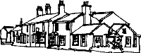
12. THE VILLAGE GREEN lies at the front of the Church and was the site of the old market cross, the base of which still survives at Meols Hall.
The present obelisk originally stood at Lathom Hall near Burscough and was erected here in the 1950s by Col Roger Fleetwood Hesketh.
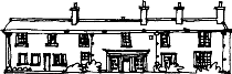 THE HESKETH ARMS PUBLIC HOUSE was originally
called the Black Bull. The building was originally three fishermen’s
cottages. At the rear can be seen the coach house.
THE HESKETH ARMS PUBLIC HOUSE was originally
called the Black Bull. The building was originally three fishermen’s
cottages. At the rear can be seen the coach house.
William Sutton, also known as ‘The Old Duke’ was landlord of the Black Bull when he opened his bathing hut at South Hawes near what is now the junction of Duke Street and Lord Street. He later built the “Original Hotel” on that site. This later became known as The Duke’s Folly.
South Hawes later became known as South Port or Southport.
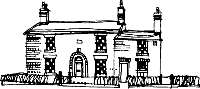
 MEOLS HALL. The first Manor
House was built by Robert de Coudray. The site
was probably chosen due to the proximity of the water mill on the Otterpool
and the sea which came up to the embankment alongside what is now Bankfield
Lane.
MEOLS HALL. The first Manor
House was built by Robert de Coudray. The site
was probably chosen due to the proximity of the water mill on the Otterpool
and the sea which came up to the embankment alongside what is now Bankfield
Lane.
In 1903 the remains of a fishing wharf were found 11 feet below the ground where the Hall gates now stand.
The present Hall was probably built during Elizabethan times but has been considerably altered over the years.
THE ROUND HOUSE AND POUND were originally situated at what is now the main entrance to the Botanic Gardens. The Round House or ‘lock up’ was demolished in 1874 but a copy was incorporated into the entrance and was used as a tram and bus shelter.
The Pound was moved to Peet’s Lane near to Churchgate.
 THE BOTANIC GARDENS
were originally opened in November 1874 by
the Southport and Churchtown Botanic Gardens Company as a place with
an almost endless variety of attractions, admission 4d.
THE BOTANIC GARDENS
were originally opened in November 1874 by
the Southport and Churchtown Botanic Gardens Company as a place with
an almost endless variety of attractions, admission 4d.
The Botanic Gardens Lake was formed from part of what was the Otter Pool or The Pool. This was a stream that flowed from Blowick through Meols Hall out to the Ribble Estuary. The monks who lived nearby fished for eels in this stream.
The Gardens closed in 1932 but were saved from being sold for housing by the Southport Corporation. They were reopened on Saturday 28th August 1937 as The Botanic Gardens and King George Playing Fields. Although the Fernery still remains the magnificent Conservatory was demolished. The outline of the remains can still be seen in front of the Fernery and are now laid out as a rose garden.
THE BOTANIC GARDENS MUSEUM was opened in 1876. The famous showman Phileus T. Barnum was an advisor and his top hat can be seen on display in the museum.
When the gardens closed before the last war, all the effects and collections were sold off. However, when the museum reopened, Mr. John Scoles, the new curator collected much new material which forms the basis of the present collection.
The museum now contains many fine collections of local interest including natural and local history, The Cecily Bate Collection of Dolls, and a Victorian Period Room. It is now the only museum in Sefton.
During the 1980s The Friends of the Botanic Gardens Museum were formed. They stopped the proposed closure of the museum and do a lot of work behind the scenes to ensure that the museum continues to stay open. Unfortunately the Museum was closed in 2011 as part of Council cutbacks.